

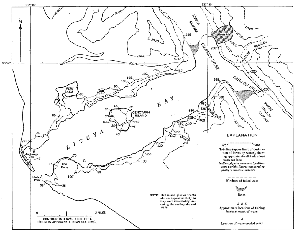
Lituya Bay, in southeast Alaska, is a beautiful place to visit but far too dangerous to live on. Local indigenous peoples have known this for centuries, and consequently have avoided settling it. Any permanent habitation established there has never lasted long. The bay itself is a fjord roughly 9 miles in length by 2 miles at maximum width. It’s the only safe haven from the ocean along a 100 mile long stretch of coastline. The west end opens to the Pacific. Notably, the entrance to the bay is shallow, limiting the size of vessels that can navigate the passage. The east end butts up against extremely steep mountains, with inlets forming a “T” to the north and south fed by enormous glaciers. Underneath these glaciers and inlets lies the Fairweather fault, a notoriously unstable geological rift.
In mid-Summer 1958, two separate mountain climbing expeditions visited Lituya to climb the peaks above the head of the bay. A Canadian team, led by Paddy Sherman, arrived by RCAF Canso (a PBY Catalina variant) flying boat on June 17. They made ascents on three peaks. The furthest, Mount Fairweather, was 25 miles distant from the bay. Mount Lituya was their third and final goal. However, warm weather caused ice near the peak to become unstable and dangerous. Although they were only 200 feet from the peak of the 11,750 feet mountain, they chose to play it safe rather than foolhardy and ended their expedition early. A radio call was made requesting the PBY to return to the bay for them on July 10. Unexpectedly, the plane arrived early in the evening on July 9 and was required to return to base that evening. (The military always has its own priorities to consider first). The Canso was airborne before 9pm, and observed three fishing boats that had taken shelter inside the mouth of the bay.
Howard Ulrich and his seven-year old son had anchored the Edrie in a cove on the south side of the bay. Awakened at 10:16pm, Ulrich got up to see what was causing all the noise. In the summertime, at northern latitudes the sun sets late in the day so there was enough light to see the mountains above the far end of the bay shaking – literally – and the side of one of the mountains slide into the water, triggering a megatsunami. The wave instantly rose to an astonishing height of 1,720 feet, wiping the side of a hill bare. In less than five minutes, it would reach them. Ultich scrambled to get his boat underway. Meanwhile, the Sunmore, crewed by the Wagners, a married couple, were already headed to the mouth of the bay hoping to beat the tsunami. They didn’t make it there in time and were never seen again. Another married couple, the Swansons, were the last to see the danger, but were lucky. When the tsunami reached them, much of its energy and height was sapped. It still had enough power to float them 80 feet above and over the spit and into the Pacific. A tree trunk punctured the hull but they escaped in their skiff. The Ulrichs were also lucky. The tsunami wasn’t as violent on the southern side of the bay where they were, and they were able to ride it out.
The strike-slip earthquake measured magnitude 7.8–8.3 on the Richter scale. The Fairview is a fast-moving fault that moved 20 feet in about one minute. The second party of mountain climbers were on the side of Mount Lituya when it struck. Incredibly, no one was injured, but when they came down from the mountain they found the terrain vastly changed, and their base camp had been washed away along with all the surrounding trees and vegetation. On the island and along the shores of the bay, huge old growth trees were washed away along with soil right down to the bedrock. Nothing was spared. A strongly built cabin on the island vanished, as did the Harbor Point lighthouse that had been at the mouth of the bay. Had the RCAF Canso not returned for Paddy Sherman’s team until July 10 as requested, the mountaineers would have all been dead.
Today, over sixty years later, the destruction to the forest surrounding the bay is still evident. Young growth has started to appear where old growth trees once stood, but it will be many more decades before the scars are completely covered over… until another big earthquake triggers the next megatsunami.
“Lituya Earthquake” (4:48)
“Tsunami in Lituya Bay” (1:03)
(computer simulation)
“TSUNAMI Height Comparison On The Earth” (3:20)
(computer simulation)