Forty-five kilometers (28 miles) off the tip of Cornwall, UK, lies an archipelago called the Isles of Scilly (49°51′56″ N, 6°23′50″ W). In the year 1707, a fleet of Royal Navy warships returning to England from the Mediterranean wrecked on the rocks of Scilly during a severe storm. As many as 2,000 British sailors were lost, with only about a dozen surviving the disaster. The cause of the catastrophe was a lack of sufficient technology to accurately determine seafaring position with precision. In short, the fleet was not where the navigators thought it was, and they crashed into the Isles of Scilly.
Accurate navigation and knowing your ship’s precise position was a pressing dilemma three centuries ago. In addition to the shock that all of Britain felt for the enormous loss of their sailing men and ships, safe navigation was critical to commerce and the economy and thus a high-priority problem to be solved. Merchants who shipped their goods overseas and investors who stood to lose large amounts of money should a vessel be lost at sea were understandably anxious to reduce the risk.
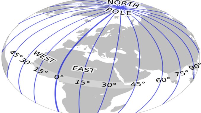
A ship’s position in terms of latitude and longitude were well-established navigation concepts long before the eighteenth century. Latitude (the imaginary east-west lines parallel to the equator) was relatively easy to determine with precision. Longitude (the imaginary north-south lines that run from north pole to south pole) however, could not be determined with adequate accuracy due to the inaccuracies of even the best clocks.
The equator was a known and fixed reference point easily found with common mariner’s instruments of the day, such as the astrolabe, the back staff (and it’s various derivations), and later the octant (circa 1730) which was supplanted by the sextant (circa 1760). All of these instruments measured angles between known references, including the Sun and the horizon, or Polaris (the North Star) and the horizon. Knowing the documented elevation of the Sun above the equator for the day of the year, and the angle between the Sun and horizon, all the navigator had to do was apply trigonometry; the distance that the ship was from the equator could be determined with reasonable accuracy. With the distance from the equator known, navigators had a fix on their latitude.
Longitude was a far trickier question due to the Earth’s rotation. With everything on Earth moving from west to east, there was no fixed reference point equivalent to the equator. Long-standing convention established that there were 360 degrees in a circle, with each degree divided into 60 minutes, and each minute divided into 60 seconds. Not coincidentally, there were 24 hours in a day, with hours divided by 60 minutes, and minutes divided into 60 seconds. (The brilliance of ancient mathematicians are to be thanked for the simplicity and genius of this arrangement). The 360 degrees of the compass divide evenly by 24, yielding 15 degrees for each hour. Also, because there are 1,440 minutes in each day (24 hours×60minutes/hour=1,440 minutes) and 1,440 divided by 360 equals 4, the Earth turns one degree on it’s axis every four minutes. Essentially, the Earth itself is a highly consistent precision clock. The problem of accurately finding one’s precise longitudinal position only required two things: a designated reference point and a precise timekeeping mechanism.
The designated reference point would become the prime meridian, meaning the beginning latitude which represented both zero degrees and 360 degrees. The place chosen would be completely arbitrary, but because the British ultimately solved the vexing problem of latitude, their chosen location of the Royal Observatory in Greenwich, England, became the accepted world standard. That left only the challenge of devising an accurate timepiece to solve.
In recognition that safer navigation could only be achieved with precision timing, and in response to the national tragedy at Scilly, the British Parliament passed the Longitude Act of 1714 which established a reward for whomever could invent a marine chronometer accurate to within certain specifications.
TO BE CONTINUED…
Question of the night: If you could solve a pressing problem, what would it be?

1 Trackback / Pingback
Comments are closed.