

Over the course of a geological epoch thirty million to ten million years ago, a lava field formed in much of the area comprised of what is now known as eastern Washington State, eastern Oregon, and part of Idaho, covering more than 100,000 square miles. A now-extinct species of rhinoceros, Diceratherium, inhabited this region at the time. Grasslands and forests of Ginkgo trees covered the land until they were smothered by lava flows. Over eons, as molten lava oozed to the surface through numerous fissures, many layers of basalt formed. In some places the cumulative depth of the layers reached thousands of feet deep.
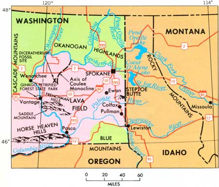
Sometime after the lava field cooled, the entire layer became tilted geologically, such that the high end rose in the east toward the Rocky Mountains and the low end sloped down toward the southwest where the Columbia River meets Oregon. Over time, winds brought dust, volcanic ash, and silt, to cover the lava fields. New fertile ground once again supported grasslands and animals, including bison, antelope, camels, and many other species.
The Great Ice Age (PDF, 3.7MB) began over two million years ago as the Arctic ice cap crept southward, covering Canada and extending into Washington, Idaho, and Montana. At times the glaciers waxed, at other times they waned. During warmer periods, melting glacier water created huge lakes. One in particular, which geologists call Lake Missoula, formed at high elevation on the eastern side of the Rocky Mountains.
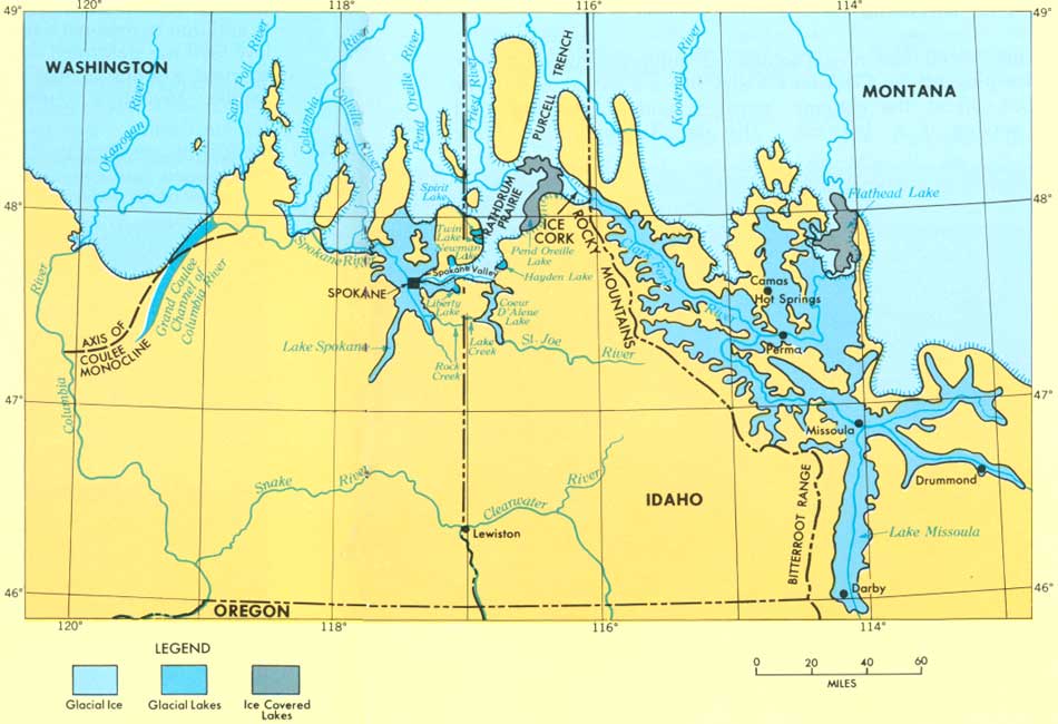
A glacier acted as a cork or dam on the west end of Lake Missoula, preventing water from escaping to the east. The glacial lake is estimated to have encompassed an area of approximately 3,000 square miles and held 500 cubic miles of water. For comparison, that’s as much water as modern Lake Erie and Lake Ontario put together, or half as much as Lake Michigan holds. Glacial Lake Missoula was almost 2,000 feet deep, which means the present-day city of Missoula, Montana, would have been 950 feet underwater.
The glacier dam is theorized to have broken several times, releasing massive floodwaters, from about 100,000 years ago until about 18,000 years ago when it broke for the final time.
The enormous volume of water and the violent currents of this flood modified or destroyed much of the evidence of earlier floods.
NPS/USGS
Each time the glacial dam broke, enormous amounts of water, giant blocks of ice, and debris, swept down out of the mountains and across the area where the lava field had formed millions of years earlier. Now, with each dam burst, soil placed there by the wind was swept away and raging water cut through the basalt rock, creating the Channeled Scablands.
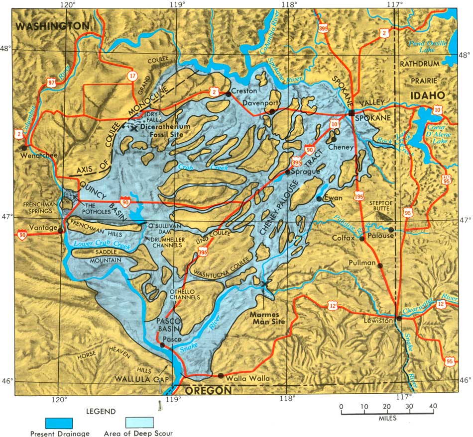
[C]urrent velocities are calculated to have reached 45 miles per hour. The maximum rate of flow is estimated to have been 9-1/2 cubic miles per hour—a rate of 386 million cubic feet per second, or about 10 times the combined flow of all the rivers of the world. For comparison, the rate of flow of the world’s largest river, the Amazon, is 6 million cubic feet per second, and the Columbia averages about 255 thousand cubic feet per second.
NPS/USGS
The flood waters moved across the territory so quickly, it’s thought that each occurrence only lasted a few days, or in some areas, a few weeks. Afterwards, the landscape was so profoundly changed that it would have been unrecognizable.
[A] deeply scarred land of bare black rock cut by labyrinthine canyons and channels, plunge pools and rock basins, cascade and cataract ledges, and displaying ragged buttes and cliffs, alcoves, immense gravel bars, and giant ripple marks.
NPS/USGS
You really need to watch this short, excellent video. It’s well worth your time. “Giant Ripples in the Scablands” (5:11):
Question of the night: What kind of rock or mineral do you favor?
1 Trackback / Pingback
Comments are closed.